


From Col Clapier you descend along the path, arriving (on the right) at the crossroads for the Rifugio Luigi Vaccarone. Continue halfway up the hill to Grange Thullie. I continue towards the Quattro Denti,...
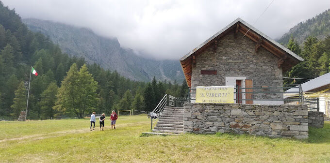
From Col Clapier you descend along the path, arriving (on the right) at the crossroads for the Rifugio Luigi Vaccarone. Continue halfway up the hill to Grange Thullie. I continue towards the Quattro Denti, a peak that can be reached in about half an hour. Immediately below Cima Quattro Denti, ignoring all the paths that lead towards the valley, continue along the hillside and keeping to the right you arrive at the Pertus di Colombano Romean (hydraulic work from 1533). Continue along the narrow path that crosses a larch forest at high altitude with beautiful views of the Exilles Fort, Salbertrand and the Oulx basin, dominated by Mount Chaberton, always maintaining the same direction until you reach the Clot Brun pasture. At this point the path ends and you take the dirt road towards the valley, blocked shortly afterwards with a rudimentary fence. Once you reach the bend below, continue into the woods along a path. You cross a first stream and then a second. The path ends shortly thereafter and you take a cart track on a grassy surface now near Grange della Valle. You cross the village between the houses, passing two fountains and exiting in front of a church. Continue on the dirt road that goes up from S.Colombano towards the bridge over the Rio di Galambra which takes its name from the valley of the same name. On the right, passing in front of the Colonia Alpina Viberti along the dirt road, you reach the Rifugio Levi Molinari in a few minutes. We start again from the Levi Molinari refuge following path 813 until the junction with path 804, thus returning to stage 2 of the historic route.

Populære turer i nabolaget
-
5,0
BARDONECCHIA Decauville
lysVandring 7,29 km -
BARDONECCHIA Colle Sommeiller
middelsTerrengsykkel 25,4 km -
SESTRIERE Assietta Road
middelsTerrengsykkel 43,3 km -
La Via dei Saraceni (Sauze d'Oulx)
middelsTerrengsykkel 33,6 km -
BARDONECCHIA Decauville - Rifugio Scarfiotti Ring
lysTerrengsykkel 34,0 km -
Sentiero Italia: Salbertrand - Bardonecchia
middelsVandring 19,5 km -
5,0
BARDONECCHIA Forte Jafferau Ring
tungTerrengsykkel 36,8 km -
Jouvenceaux-Gad/Cotantin (n°9)
lysVandring 2,82 km -
BARDONECCHIA Forte Foens - Galleria dei Saraceni - Forte Pramand
middelsTerrengsykkel 34,3 km -
Col du Mont Cenis from Modane
middelsRennrad 34,8 km
Vandring og sporing


Ikke gå glipp av tilbud og inspirasjon til din neste ferie
E-postadressen din har blitt lagt til på adresselisten.